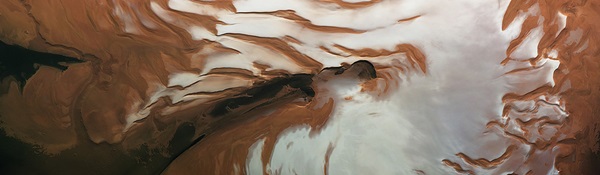
A newly released image from ESA’s Mars Express shows the north pole of Mars during the Red Planet’s summer solstice. All the carbon dioxide ice has gone, leaving just a bright cap of water ice.
This image, captured by the orbiter’s High-Resolution Stereo Camera on May 17, 2010, shows part of the northern polar region of Mars during the summer solstice. The solstice is the longest day and the beginning of the summer for the planet’s northern hemisphere.
The ice shield is covered by frozen water and carbon dioxide ice in winter and spring, but by this point in the martian year all of the carbon dioxide ice has warmed and evaporated into the planet’s atmosphere.
Only water ice is left behind, which shows up as bright white areas in this picture. From these layers, large bursts of water vapor are occasionally released into the atmosphere.
The polar ice follows the seasons. In winter, part of the atmosphere recondenses as frost and snow on the northern cap. These seasonal deposits can extend as far south as 45° north latitude and can be up to a meter thick.
Another phenomenon occurs on the curved scarps of the northern polar cap, such as the Rupes Tenuis slope (on the left of this image). During spring, the seasonal carbon dioxide layer is covered by water frost. At certain times, winds remove the millimeter-thick top layer of frozen water, revealing the carbon dioxide ice below.
These processes bear witness to a dynamic water cycle on Mars and may lead to the varying accumulation of water ice over the polar cap.
Other noticeable features in this image include the Chasma Boreale canyon, colored deposits, and a large dune field. Chasma Boreale is about 1 mile (2 kilometers) deep, 360 miles (580 km) long, and about 60 miles (100 km) wide. Its walls allow a perfect view into the strata within the deposits. There are impact craters on the canyon floor, some heavily covered by sand and some partly exhumed.
Dark and light-toned deposits can be seen as a fine and regular covering. The darker sediments have been dropped by the winds during spring dust storms. The patterns are created when the deposits change in quantity according to the seasons.
The polar cap is surrounded by a large dune field, parts of which extend 370 (600 km) to the south.
Mars Express will soon be using its radar to probe the northern polar cap in three dimensions. Since the radar antenna was deployed in mid-2005, the team has been waiting for the right conditions to observe the region.
The radar works best at night when the electrical interference from the planet’s atmosphere is at a minimum. An excellent opportunity to observe the cap’s shape, depth, and composition occurs in August and September 2011.