Happy eclipse day! Here’s a guide to the 2023 “Ring of Fire” annular eclipse, which begins at 11:04 a.m. EDT on Saturday, Oct. 14.
We’ve included details in this article on the best places to see the eclipse and what exactly it is. If you just want the TL/DR version, here are some quick facts and links to view NASA’s multiple livestreams of the celestial event.
- The 2023 eclipse begins at 11:04 A.M EDT. Its path begins in the Pacific Ocean, crosses the west/southwestern U.S. from Oregon to Texas and continues through Mexico, Belize, Guatemala, Honduras, Nicaragua, Costa Rica, Panama, Colombia and Brazil.
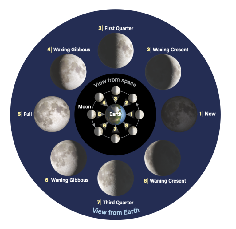
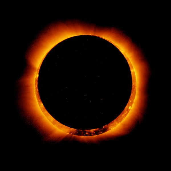
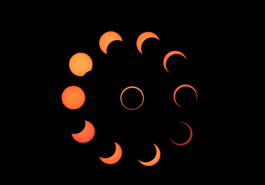
- The “Ring of Fire” is an annular eclipse, which happens when the Sun, the Moon and the Earth line up. This is not a total eclipse but it’s still amazing. It’s called a ring of fire because the Moon does not appear to cover the entire Sun. The next total eclipse is April 8, 2024.
- Don’t look directly at the eclipse. Because the Moon doesn’t completely cover the Sun, you must “use an approved solar filter (one that meets the ISO 12312–2 international safety standard) during the entire eclipse. This means over your eyes, your camera, and your binoculars or telescope.” More on that below.
- Albuquerque and San Antonio are the two major American cities that are directly in the path of the eclipse. Weather permitting, several hundred million more people will be able to see it.
- Worth repeating: Don’t look directly at the eclipse. NASA has some great tips here on how to see it if you don’t have approved solar filters.
- Here are the NASA livestreams to see the eclipse (we’ve included one below, too):
What is the annular eclipse?
The official name is an annular eclipse, which occurs when the Sun, the Moon, and Earth line up, just like a total eclipse. In this case, however, either the Sun is too close or the Moon is too far from Earth for the Moon to completely cover the solar disk. So, only the antumbra, where the Moon appears completely within the disk of the Sun, touches the surface of Earth. Anyone within the path will see a ring of the Sun’s surface surrounding the darkened Moon.
On Oct. 14, an annular eclipse will cross the western U.S. from Oregon to Texas. Afterward, it will touch nine additional countries: Mexico, Belize, Guatemala, Honduras, Nicaragua, Costa Rica, Panama, Colombia, and Brazil.
In the U.S., approximately 6.6 million people lie in the path of annularity; only include two major cities – Albuquerque and San Antonio – lie in the path. Several hundred million more will see a partial eclipse, weather permitting.
Please note that because part of the Sun’s surface is always visible, you must use an approved solar filter (one that meets the ISO 12312–2 international safety standard) during the entire eclipse. This means over your eyes, your camera, and your binoculars or telescope — NO EXCEPTIONS!
When will the annular eclipse begin?
The eclipse starts when the Moon’s penumbra (its lighter, outer shadow where a partial eclipse occurs) touches Earth at 11:04 a.m. EDT. That happens nearly 970 miles (1,560 kilometers) south of Ketchikan, Alaska, in the North Pacific Ocean.
The annular part of the eclipse begins at 12:10 p.m. EDT and ends at 3:49 p.m. EDT about 360 miles (580 km) off the coast of Brazil. Greatest eclipse occurs at 1:59 p.m. EDT in the Caribbean Sea, 60 miles (97 km) from the coast of Nicaragua. The last remnants of the Moon’s shadow disappear into the night over northeastern Brazil at 4:55 p.m. EDT, about 220 miles (350 km) northeast of the Brazilian capital of Brasília. The shadow will have stayed on Earth’s surface for 5 hours 51 minutes 29 seconds.
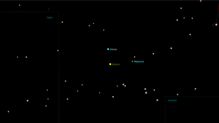
The magnitude of this eclipse is 0.952. This means that, as seen from Earth, the Moon’s diameter is 95.2 percent as large as the Sun’s diameter. At the eclipse’s maximum, the Moon will cover 90.6 percent of our daytime star with annularity lasting 5 minutes 17 seconds. The eclipse will take place in the constellation Virgo, about 4° to the upper right of Spica (Alpha [α] Virginis), which will be invisible. Venus, some 46° west-northwest of the Sun, will be the only object in the sky bright enough to see. At magnitude –4.6, the planet should become visible several minutes before maximum eclipse. Because it’s so far from the Sun, you can safely search for it through binoculars.
Oregon and California

The first part of the eclipse sees the antumbra traveling some 1,100 miles (1,770 km) over the northern Pacific Ocean. It touches land on the U.S. coast just west of Gardiner, Oregon, at 9:13 a.m. PDT. Annularity here will last 4 minutes 24 seconds.
A great opportunity for photographers will occur just 125 miles (200 km) farther along the path as Crater Lake also enjoys 4 minutes 24 seconds of annularity. But be sure to check the availability of the roads around the lake — closings because of snow have happened by mid-October.
The antumbra continues to the southeast and next covers the extreme northeast corner of California. Tiny New Pine Creek, just east of Goose Lake, will experience 4 minutes 7 seconds of annularity.
Nevada, Idaho, and Utah
Annularity will begin in northwest Nevada at 9:19 a.m. PDT and end at the Utah border 10 minutes later. Note that in Utah, the time zone is Mountain Daylight Time. Maximum annularity in Nevada is between 4 minutes 33 seconds and 4 minutes 37 seconds, and the Sun’s altitude climbs to 27° at the Utah border.
With a population around 20,000, the largest Nevada town touched by annularity is Elko. Access is easy because of Interstate 80, and there’s a 70 percent chance of sunshine.
In Idaho, only a tiny triangle with an area of 43 square miles (111 square km) sees annularity, but there are no towns in this region.
In Utah, the annular eclipse begins just west of Gandy at 10:24 a.m. MDT. The path passes over some gorgeous landscapes, but no large cities. However, both I-70 and I-15 allow easy drives to dozens of great locations.
Eclipse watchers into geography might choose to view from the Four Corners Monument, where the states of Utah, Colorado, New Mexico, and Arizona meet. That spot will feature 4 minutes 30 seconds of annularity with the Sun 33° high.
Arizona
The annular part of the eclipse reaches Arizona at 9:29 a.m. MDT, approximately 37 miles (60 km) east of Page, which lies outside the path. Eclipse chasers should drive south 66 miles (106 km) along State Route 98 and then another 87 miles (140 km) east on U.S. Highway 160 to Red Mesa. There, annularity lasts 4 minutes 41 seconds.
Flagstaff doesn’t get annularity, but will be a base for eclipse chasers. Anyone staying there can drive 68 miles (109 km) north on U.S. Highway 89, and then take U.S. Highway 160 to the path.
Colorado
Three minutes after the antumbra touches Arizona, it enters Colorado about 12 miles (19 km) northwest of Dove Creek. The state’s best viewing spot is the far southwestern corner, where U.S. Highway 160 enters Arizona. There, annularity lasts 4 minutes 30 seconds.
Photographers might want to head to Canyons of the Ancients National Monument. The duration of annularity drops to 3 minutes 19 seconds, but the density of archaeological remains is the highest in the U.S.
New Mexico
The first large city covered by the antumbra during this eclipse will be Albuquerque. Its more than a half-million residents will enjoy 4 minutes 42 seconds of annularity. Santa Fe, closer to the northern limit, gets two minutes less.
Those with a sense of irony might choose to view the annular eclipse from the village of Corona (4 minutes 36 seconds of annularity). Or perhaps you have a sense of humor and would enjoy the festivities in Roswell (4 minutes 30 seconds), where, in 1947, a “flying disc” supposedly crashed north of the city.
Texas
Texas first gets annularity at 11:41 a.m. CDT, 25 miles (40 km) west of Tatum, New Mexico. Note that Texas observes Central Time. One astronomy destination in Texas is Odessa, home of the Odessa Meteor Crater. Anyone there will experience 4 minutes 20 seconds of annularity. For 28 more seconds of annularity, drive 23 miles (37 km) northeast to the center line.
As the antumbra moves toward the Gulf of Mexico, it covers a lot of populated territory. No less than three interstate highways — I-10, I-35, and I-37 — run hundreds of miles through this area. The towns of Midkiff, Stiles, Barnhart, and Sonora lie on or near the center line.
And then the eclipse comes to San Antonio. The metro area’s 2.6 million residents will see between 3 minutes 24 seconds and 4 minutes 44 seconds of annularity. The northeastern parts of the metro area will have the least time and those in the southwest suburbs will enjoy the most. And talk about photographic opportunities!
The Alamo Mission — the No. 1 tourist attraction in Texas — certainly will be high on the list. Annularity there will last 4 minutes 5 seconds. To capture both the eclipsed Sun and the Alamo, seek out a spot to the north-northwest. Right next to the Alamo is another photogenic site, the Hemisfair park, with its 750-foot-tall (229 meters) Tower of the Americas.
Finally, 130 miles (209 km) southeast of San Antonio, the annular eclipse comes to the coast at Corpus Christi. Viewers just north of downtown will enjoy annularity lasting up to 4 minutes 53 seconds. The actual last point of contact for the antumbra in the U.S. happens at 12:01 p.m. CDT on Padre Island on the Gulf Coast.

Mexico
After a quick trip across the Gulf of Mexico, the antumbra reaches the state of Yucatán, Mexico, at 12:21 p.m. CDT, where photographers can capture the eclipsed Sun above several ancient archaeological sites. Uxmal, one of the great cities of the Mayans, lies about 37 miles (60 km) south of Merida. There, annularity will last 3 minutes 50 seconds.
Another Mayan archaeological site with even more annularity is Edzná, which lies southeast of Campeche City. There, annularity will last 4 minutes 32 seconds. After these highlights, only a few small towns lie along the center line. One is Nicolás Bravo,where annularity will last 5 minutes 1 second.
Central America
At 11:29 p.m. Belize Time, the Moon’s antumbra will cross the Hondo River north of Orange Walk Town. From the center line there, the roughly 15,000 residents will enjoy 5 minutes 1 second of annularity. The capital, Belmopan, will have 2 minutes 45 seconds, and Belize City will have 5 minutes of annularity.
Then the antumbra arrives in Honduras. The country’s third-largest city, La Ceiba, just west of the center line, will enjoy 5 minutes of annularity.
Nicaragua is next. The best place to view the eclipse is Bluefields, which lies on the eastern coast. The center line passes just north of the city, which will see 5 minutes 5 seconds of annularity.
Costa Rica doesn’t get much annularity, but Panama’s northwestern region will experience an annular eclipse lasting between two and four minutes. The greatest duration of annularity over land — 5 minutes 7 seconds — is in the northern part of Santa Fé National Park.
South America
On this continent, the Moon’s antumbra travels over only two countries. In Colombia, the largest city covered is Cali, where annularity will last from 2 minutes 54 seconds to 3 minutes 43 seconds.
As the eclipse moves into Brazil, annularity begins along the center line at 2:55 p.m. Amazon Time, some 30 miles (48 km) due north of the village of La Pedrera. The largest city covered is Natal, which will experience between 3 minutes 10 seconds and 3 minutes 40 seconds of annularity. Then, at 4:48 p.m. Brasília Time, the antumbra begins its final 400-mile (644 km) journey over open water, ending at sunset.
A total solar eclipse is coming April 8, 2024
As cool as this annular eclipse will be, it’s just a warm-up for a much more spectacular event. Less than six months from Oct. 14, a total solar eclipse will cross the U.S. on April 8, 2024. So, see this one if you can, but do not miss totality!