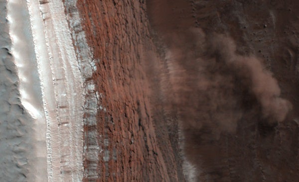
A NASA spacecraft in orbit around Mars has taken the first ever image of active avalanches near the Red Planet’s north pole. The image shows tan clouds billowing away from the foot of a towering slope, where ice and dust have just cascaded down.
The High Resolution Imaging Experiment (HiRISE) on NASA’s Mars Reconnaissance Orbiter took the photograph February 19. It is one of approximately 2,400 HiRISE images being released today.
Ingrid Daubar Spitale of the University of Arizona, Tucson, who works on targeting the camera and has studied hundreds of HiRISE images, was the first person to notice the avalanches. “It really surprised me,” she says. “It’s great to see something so dynamic on Mars. A lot of what we see there hasn’t changed for millions of years.”
The camera is looking repeatedly at selected places on Mars to track seasonal changes. However, the main target of the image was not the steep slope.
“We were checking for springtime changes in the carbon-dioxide frost covering a dune field, and finding the avalanches was completely serendipitous,” says Candice Hansen, deputy principal investigator for HiRISE at NASA’s Jet Propulsion Laboratory.
The full image reveals features as small as a desk in a strip of terrain 3.7 miles (6 kilometers) wide and more than 10 times that long, at 84° north latitude. Reddish layers known to be rich in water ice make up the face of a steep slope more than 2,300 feet (700 meters) tall, running the length of the image.
“We don’t know what set off these landslides,” says Patrick Russell of the University of Berne, Switzerland, a HiRISE team collaborator. “We plan to take more images of the site through the changing martian seasons to see if this kind of avalanche happens all year or is restricted to early spring.”
More ice than dust probably makes up the material that fell from the upper portion of the scarp. Imaging of the site during coming months will track any changes in the new deposit at the base of the slope. That will help researchers estimate what proportion is ice.
“If blocks of ice broke loose and fell, we expect the water in them will be changing from solid to gas,” Russell says. “We’ll be watching to see if blocks and other debris shrink in size. What we learn could give us a better understanding of one part of the water cycle on Mars.”
The camera is one of six science instruments on the orbiter. The spacecraft reached Mars in March 2006 and has returned more data than all other current and past missions to Mars combined.
“Our Mars program is the envy of the world,” says Alan Stern, associate administrator of NASA’s Science Mission Directorate, Washington. “We plan to launch a total of five more missions in the next decade, beginning with the Mars Science Lab rover next year and a Mars Aeronomy Scout mission in 2011.”