New images from the Mars Global Surveyor spacecraft, which has been orbiting the Red Planet since 1997, show how gullies, impact craters, rock falls, and eroding polar icescapes rework Mars’ surface today. The long-lived mission has revealed a dynamic Mars changing on human timescales of years to decades, says Michael Meyer, lead scientist for NASA’s Mars Exploration Program.
“These new images are important because they catch martian processes in action,” says Jack Mustard, a planetary scientist at Brown University in Rhode Island.
Some of the planet’s most dramatic terrain alteration is happening at its south polar residual cap. The residual ice cap is the portion that remains bright and retains ice throughout the austral summer. The ice is frozen carbon dioxide (CO2) — dry ice — and is sculpted into broad mesas, buttes, and small circular pits that, in some places, resemble stacks of thinly sliced Swiss cheese. But the ice cap is disappearing.
“It’s evaporating right now at a prodigious rate,” says Michael Malin, principal investigator for the Mars Orbiter Camera (MOC) that took the images. “We’re losing about 3 meters [10 feet] of escarpment each Mars year.” Over time, the polar pits merge into plains, mesas shrink into buttes, and buttes vanish forever.
“The significance of this is that Mars is experiencing climate change … because the present conditions are not conducive to the formation of all this CO2 … in the polar region,” Malin says. “So, sometime in the distant past, Mars was cold enough — and colder than it is now — to form a permanent CO2 deposit.” The martian climate then warmed and began eroding this deposit.
“Why is Mars warmer today than it was in the past? We really have no way of knowing,” says Malin.
New gully
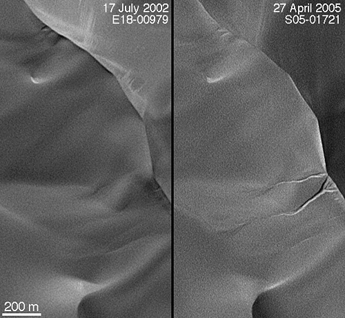
MOC images also show the formation of gullies along the steep slope of a sand dune in an unnamed crater west of the planet’s Hellas Basin. The longest of the new gullies measures about half a mile (850 meters) long, as much as 130 feet (40m) wide, and just a few yards deep. Although the flow of water has been implicated in other types of gullies, Malin thinks dune gullies form differently.
“It’s very, very hard for water to flow on a sand dune because sand is so porous,” Malin says. “What we think is going on here is that carbon-dioxide snow has been incorporated into the sand dune.” Windblown sand may bury snowy patches, a process known to occur in Antarctica. When sunlight eventually hits the snow, it turns into a gas and “fluidizes” the sand, helping it flow in a manner more similar to a liquid than an avalanche.
Fading crater
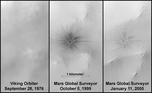
Impact cratering has been called the solar system’s most common geological process, but planetary scientists almost never have a chance to see fresh craters. Mars Global Surveyor has found perhaps half a dozen small, obviously new, impact craters. The best example, is a 65-foot-wide (20m) bowl centered in a splash of dark, rayed ejecta. It lies near the rim of Ulysses Patera, the caldera of an ancient volcano.
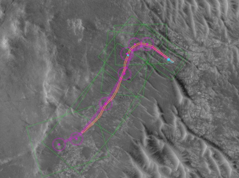
“The rays are dark because of the ejecta disturbing the dust-covered surface,” says Malin, which is also why the camera can spot the tracks of the Mars Exploration Rovers Spirit and Opportunity.
The crater is obvious in a 1999 Mars Orbiter Camera image, but in 2005, the ejecta has nearly faded into the surrounding terrain. Moreover, there’s no hint of the crater in an earlier image, returned in 1976 by one of the Viking orbiters. “This was a crater that didn’t exist 20 years ago,” Malin says. It was probably created by an object just a few feet across.
Although MOC has observed only about 4 percent of the martian surface, Malin notes the number of fresh craters is lower than planetary scientists anticipated. Because scientists use the number of craters to infer the age of a planetary surface, a lower rate of crater formation would make surfaces on Mars older.
“I suspect that the reason why the cratering rate looks different is that impact cratering comes in clusters. There are pulses in that bombardment. There are times when the impact rate will be lower,” Malin explains. “We’re in a lull at Mars.”
Other images included a recent rock fall, in which several boulders left tracks as they rolled and bounced down a crater wall. “It’s the first we have found that had actually occurred while we were observing,” Malin says. The rocks tumbled sometime between November 2003 and December 2004. Strong winds, a nearby impact, or an earthquake — or rather, a marsquake — could have dislodged them. “The rock fall is evidence that there was some kind of disturbance,” Malin says.
Mars Global Surveyor arrived at Mars September 12, 1997. After gradually adjusting the shape of its orbit, it began systematically mapping the planet in March 1999 and completed its primary mission in 2001. Now halfway through its third mission extension, which ends October 2006, the durable spacecraft has been productive longer than any other sent to the Red Planet. To date, the craft has returned some 200,000 images — more than all previous Mars missions combined. The spacecraft is healthy, says Malin, and carries enough maneuvering fuel to last through the rest of the decade.
Its Mars Orbiter Camera acquires the highest-resolution images obtained by a Mars-orbiting spacecraft, revealing objects as small as 13 feet (4m) across. Scientists at Malin Space Science Systems have developed techniques to double this resolution by rotating the spacecraft so it tracks a target as it orbits.
NASA’s Mars Reconnaissance Orbiter (MRO) is expected to arrive at the Red Planet in March. It will join NASA’s Global Surveyor and Mars Odyssey, as well as the European Space Agency’s Mars Express, in their continuing missions.