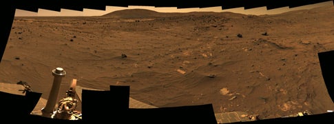
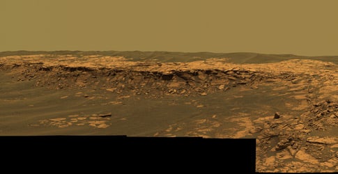
After sitting at a favorable location during the martian winter, Spirit’s panoramic camera (Pancam) began taking exposures April 18, 2006 (sol 814) for the McMurdo Panorama. Spirit has acquired more than 900 images so far for this panorama. This portion looks north, with Husband Hill on the horizon near the center.
NASA/JPL/Cornell
“Portraits sent from Mars” appeared in the January 2007 issue of Astronomy. Space limitations didn’t allow us to show many of the spectacular images taken by the rovers. So, here are more great portraits sent from Mars.
Winter roost
After sitting at a favorable location during the martian winter, Spirit’s panoramic camera (Pancam) began taking exposures April 18, 2006 (sol 814) for the McMurdo Panorama. Spirit has acquired more than 900 images so far for this panorama. This portion looks north, with Husband Hill on the horizon near the center. NASA/JPL/Cornell
After sitting at a favorable location during the martian winter, Spirit’s panoramic camera (Pancam) began taking exposures April 18, 2006 (sol 814) for the McMurdo Panorama. Spirit has acquired more than 900 images so far for this panorama. This portion looks north, with Husband Hill on the horizon near the center. NASA/JPL/Cornell
Tennessee Valley postcard
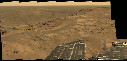
Spirit took this “postcard” or mini-panorama August 23, 2005 (sol 582), just as the rover completed its climb up Husband Hill. The summit appears to be a windswept plateau of scattered rocks, little sand dunes, and small outcroppings. The breathtaking view here looks north, down into the drifts and outcrops of the Tennessee Valley, a region Spirit was not able to visit during its climb to the top of the hill. The approximate true-color portrait spans about 90°. NASA/JPL-CALTECH/Cornell
Spirit took this “postcard” or mini-panorama August 23, 2005 (sol 582), just as the rover completed its climb up Husband Hill. The summit appears to be a windswept plateau of scattered rocks, little sand dunes, and small outcroppings. The breathtaking view here looks north, down into the drifts and outcrops of the Tennessee Valley, a region Spirit was not able to visit during its climb to the top of the hill. The approximate true-color portrait spans about 90°. NASA/JPL-CALTECH/Cornell
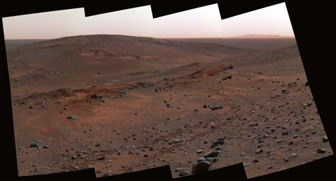
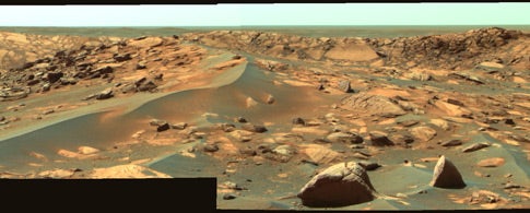
Spirit approaches an outcrop dubbed Methuselah. The rover examined the outcrop for several days before resuming its uphill climb. Scientists assembled this false-color view from frames taken by Spirit’s panoramic camera April 13, 2005 (sol 454). The outcrop on the right, with rover tracks leading from it, is Larry’s Lookout.
NASA/JPL/Cornell
Break time
Spirit approaches an outcrop dubbed Methuselah. The rover examined the outcrop for several days before resuming its uphill climb. Scientists assembled this false-color view from frames taken by Spirit’s panoramic camera April 13, 2005 (sol 454). The outcrop on the right, with rover tracks leading from it, is Larry’s Lookout. NASA/JPL/Cornell
Spirit approaches an outcrop dubbed Methuselah. The rover examined the outcrop for several days before resuming its uphill climb. Scientists assembled this false-color view from frames taken by Spirit’s panoramic camera April 13, 2005 (sol 454). The outcrop on the right, with rover tracks leading from it, is Larry’s Lookout. NASA/JPL/Cornell
NASA dubbed this view Spirit’s Legacy panorama. It combines many frames acquired during Spirit’s 59th through 61st martian days, or sols, (March 3 to 5, 2004) from a position about halfway between the landing site and the rim of Bonneville Crater. The location lies within the transition from the relatively smooth plains to the more rocky and rugged blanket of material ejected from Bonneville by the force of the impact that dug the crater. The panorama spans 360° and comprises images obtained in 78 individual pointings. The camera took images though 5 different filters at each pointing to render this near true-color image. The Columbia Memorial Station lander lies about 650 feet (200 meters) in the distance. Just follow the rover tracks back toward right of center.
NASA/JPL/Cornell
Martian legacy
NASA dubbed this view Spirit’s Legacy panorama. It combines many frames acquired during Spirit’s 59th through 61st martian days, or sols, (March 3 to 5, 2004) from a position about halfway between the landing site and the rim of Bonneville Crater. The location lies within the transition from the relatively smooth plains to the more rocky and rugged blanket of material ejected from Bonneville by the force of the impact that dug the crater. The panorama spans 360° and comprises images obtained in 78 individual pointings. The camera took images though 5 different filters at each pointing to render this near true-color image. The Columbia Memorial Station lander lies about 650 feet (200 meters) in the distance. Just follow the rover tracks back toward right of center. NASA/JPL/Cornell
NASA dubbed this view Spirit’s Legacy panorama. It combines many frames acquired during Spirit’s 59th through 61st martian days, or sols, (March 3 to 5, 2004) from a position about halfway between the landing site and the rim of Bonneville Crater. The location lies within the transition from the relatively smooth plains to the more rocky and rugged blanket of material ejected from Bonneville by the force of the impact that dug the crater. The panorama spans 360° and comprises images obtained in 78 individual pointings. The camera took images though 5 different filters at each pointing to render this near true-color image. The Columbia Memorial Station lander lies about 650 feet (200 meters) in the distance. Just follow the rover tracks back toward right of center. NASA/JPL/Cornell
Opportunity acquired this false-color image of the rim of the 115-foot-diameter (35-meter) Beagle Crater July 30, 2006 (sol 894). At the time, the rover was about 82 feet (25m) from Beagle Crater, looking east-southeast. The image reveals ejecta blocks near the rover, the largest of which is about 20 inches (50 centimeters) across. The image also shows a portion of the eastern interior rim of Beagle Crater, which appears composed of jumbled, angular blocks of brighter and darker outcrop rocks.
NASA/JPL-CALTECH/Cornell
Living on the edge
Opportunity acquired this false-color image of the rim of the 115-foot-diameter (35-meter) Beagle Crater July 30, 2006 (sol 894). At the time, the rover was about 82 feet (25m) from Beagle Crater, looking east-southeast. The image reveals ejecta blocks near the rover, the largest of which is about 20 inches (50 centimeters) across. The image also shows a portion of the eastern interior rim of Beagle Crater, which appears composed of jumbled, angular blocks of brighter and darker outcrop rocks. NASA/JPL-CALTECH/Cornell
Opportunity acquired this panorama of the Payson outcrop on the western edge of Erebus Crater February 26, 2006 (sol 744). Here, at the northern end of the outcrop, we see layered rocks in the crater wall, which is about 3.3 feet (1 meter) thick. The view also shows rocks disrupted by the impact that formed the crater. Opportunity took 28 separate exposures of this scene, using four different filters. The resulting approximately true-color rendering covers about 90° of terrain around the rover.
NASA/JPL-CALTECH/USGS/Cornell
Impact crater
Opportunity acquired this panorama of the Payson outcrop on the western edge of Erebus Crater February 26, 2006 (sol 744). Here, at the northern end of the outcrop, we see layered rocks in the crater wall, which is about 3.3 feet (1 meter) thick. The view also shows rocks disrupted by the impact that formed the crater. Opportunity took 28 separate exposures of this scene, using four different filters. The resulting approximately true-color rendering covers about 90° of terrain around the rover. NASA/JPL-CALTECH/USGS/Cornell
Opportunity acquired this panorama of the Payson outcrop on the western edge of Erebus Crater February 26, 2006 (sol 744). Here, at the northern end of the outcrop, we see layered rocks in the crater wall, which is about 3.3 feet (1 meter) thick. The view also shows rocks disrupted by the impact that formed the crater. Opportunity took 28 separate exposures of this scene, using four different filters. The resulting approximately true-color rendering covers about 90° of terrain around the rover. NASA/JPL-CALTECH/USGS/Cornell
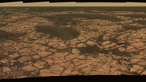
This view from Opportunity shows an outcrop called Olympia along the northwestern margin of Erebus crater. The view spans about 120°, looking southward. The outcrop exposes a broad expanse of sulfate-rich sedimentary rocks. The rocks formed predominantly from windblown sediments, but some also formed in damp conditions or under shallow surface water.
NASA/JPL-CALTECH/Cornell
No lack of targets
This view from Opportunity shows an outcrop called Olympia along the northwestern margin of Erebus crater. The view spans about 120°, looking southward. The outcrop exposes a broad expanse of sulfate-rich sedimentary rocks. The rocks formed predominantly from windblown sediments, but some also formed in damp conditions or under shallow surface water. NASA/JPL-CALTECH/Cornell
This view from Opportunity shows an outcrop called Olympia along the northwestern margin of Erebus crater. The view spans about 120°, looking southward. The outcrop exposes a broad expanse of sulfate-rich sedimentary rocks. The rocks formed predominantly from windblown sediments, but some also formed in damp conditions or under shallow surface water. NASA/JPL-CALTECH/Cornell
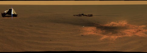
This stunning image features Opportunity’s heat-shield impact site. Opportunity acquired this mosaic December 28, 2004 (sol 330), shortly after it arrived to investigate the site where its heat shield struck Mars south of Endurance Crater January 24, 2004. On the left, the main heat-shield piece is inverted and reveals its metallic insulation layer, glinting in the sunlight. The main piece stands about 3.3 feet (1 meter) tall and about 43 feet (13m) from the rover. The other large, flat piece of debris near the center lies about 46 feet (14m) away. The circular feature on the image’s right side is the crater made by the heat shield’s impact. The crater measures about 9.2 feet (2.8m) in diameter but only about 2 to 4 inches (5 to 10 centimeters) deep and sits about 20 feet (6 meters) from Opportunity. Smaller fragments and debris can be seen all around the impact site.
NASA/JPL/Cornell
Impressive impact
This stunning image features Opportunity’s heat-shield impact site. Opportunity acquired this mosaic December 28, 2004 (sol 330), shortly after it arrived to investigate the site where its heat shield struck Mars south of Endurance Crater January 24, 2004. On the left, the main heat-shield piece is inverted and reveals its metallic insulation layer, glinting in the sunlight. The main piece stands about 3.3 feet (1 meter) tall and about 43 feet (13m) from the rover. The other large, flat piece of debris near the center lies about 46 feet (14m) away. The circular feature on the image’s right side is the crater made by the heat shield’s impact. The crater measures about 9.2 feet (2.8m) in diameter but only about 2 to 4 inches (5 to 10 centimeters) deep and sits about 20 feet (6 meters) from Opportunity. Smaller fragments and debris can be seen all around the impact site. NASA/JPL/Cornell
This stunning image features Opportunity’s heat-shield impact site. Opportunity acquired this mosaic December 28, 2004 (sol 330), shortly after it arrived to investigate the site where its heat shield struck Mars south of Endurance Crater January 24, 2004. On the left, the main heat-shield piece is inverted and reveals its metallic insulation layer, glinting in the sunlight. The main piece stands about 3.3 feet (1 meter) tall and about 43 feet (13m) from the rover. The other large, flat piece of debris near the center lies about 46 feet (14m) away. The circular feature on the image’s right side is the crater made by the heat shield’s impact. The crater measures about 9.2 feet (2.8m) in diameter but only about 2 to 4 inches (5 to 10 centimeters) deep and sits about 20 feet (6 meters) from Opportunity. Smaller fragments and debris can be seen all around the impact site. NASA/JPL/Cornell
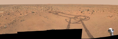
This section of Spirit’s first color image looks at a trail left by the one of the rover’s airbags. The drag mark was made after the rover landed and its airbags were deflated and retracted. Scientists dubbed the region the Magic Carpet. The airbags also dragged rocks, leaving impressions and bow waves in the soil. Spirit’s panoramic camera took this image January 9, 2004 (sol 7).
NASA/JPL/Cornell
Magic carpet ride
This section of Spirit’s first color image looks at a trail left by the one of the rover’s airbags. The drag mark was made after the rover landed and its airbags were deflated and retracted. Scientists dubbed the region the Magic Carpet. The airbags also dragged rocks, leaving impressions and bow waves in the soil. Spirit’s panoramic camera took this image January 9, 2004 (sol 7). NASA/JPL/Cornell
This section of Spirit’s first color image looks at a trail left by the one of the rover’s airbags. The drag mark was made after the rover landed and its airbags were deflated and retracted. Scientists dubbed the region the Magic Carpet. The airbags also dragged rocks, leaving impressions and bow waves in the soil. Spirit’s panoramic camera took this image January 9, 2004 (sol 7). NASA/JPL/Cornell
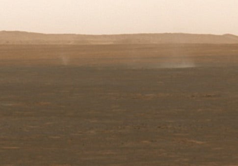
Spirit took this false-color image of dust devils moving across the plains of Gusev, near Spirit’s landing site, August 4, 2005 (sol 564). Spirit began seeing dust activity near the beginning of Mars’ spring season.
NASA/JPL/Cornell/Texas A&M
Dust devils
Spirit took this false-color image of dust devils moving across the plains of Gusev, near Spirit’s landing site, August 4, 2005 (sol 564). Spirit began seeing dust activity near the beginning of Mars’ spring season.
NASA/JPL/Cornell/Texas A&M
Spirit took this false-color image of dust devils moving across the plains of Gusev, near Spirit’s landing site, August 4, 2005 (sol 564). Spirit began seeing dust activity near the beginning of Mars’ spring season.
NASA/JPL/Cornell/Texas A&M