A geologic mapping project using NASA spacecraft data offers new evidence that expansive lakes existed long ago on Mars.
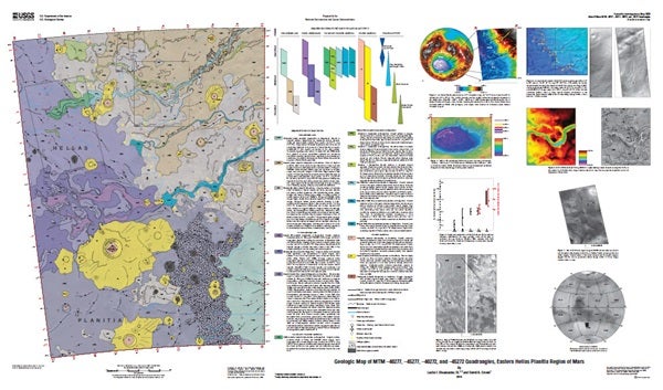
The research points to a series of sedimentary deposits consistent with what would relate to large standing bodies of water in Hellas Planitia located in the southern hemisphere of Mars, said Leslie Bleamaster, research scientist at the Planetary Science Institute, Tucson, Arizona.
Fine-layered outcrops around the eastern rim of Hellas have been interpreted as a series of sedimentary deposits resulting from erosion and transport of highland rim materials into a basin-wide standing body of water, Bleamaster said. Hellas Basin, more than 1,200 miles (2,000 kilometers) across and 5 miles (8 kilometers) deep, is the largest recognized impact structure on the martian surface, he said.
The mapping project reinforces earlier research that initially proposed Hellas-wide lakes, citing different evidence in the west, he said.
“This mapping makes geologic interpretations consistent with previous studies and constrains the timing of these putative lakes to the early-middle Noachian period on Mars, between 4.5 and 3.5 billion years ago,” he said.
A systematic search of high-resolution images revealed that eastern Hellas Planitia, where the fine-layered floor deposits were discovered, is unique in nature, representing a confluence between sedimentary sources and sinks. The circum-Hellas highlands represent a significant percentage of the southern hemisphere of Mars, and they have served as a locus for volcanic and sedimentary activity throughout martian geologic time. Hellas Planitia preserves the materials shed from these highlands and holds the key to further unraveling some of Mars’ long-held secrets.
“Our mapping and evaluation of landforms and materials of the Hellas region from the basin rim to floor provides further insight into martian climate regimes and into the abundance, distribution, and flux of volatiles through history,” Bleamaster said.
To download the map, visit http://pubs.usgs.gov/sim/3096