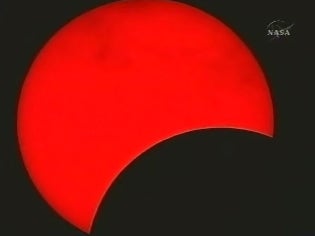
This image of the total solar eclipse was taken at 6:35 A.M.
Provided by NASA TV
August 1, 2008
On August 1, a total solar eclipse was visible in parts of Canada, northern Greenland, the Arctic, central Russia, Mongolia and China. The eclipse swept across Earth in a narrow path that began in Canada’s northern province of Nunavut and ended in northern China’s Silk Road region.
On August 1, a total solar eclipse was visible in parts of Canada, northern Greenland, the Arctic, central Russia, Mongolia and China. The eclipse swept across Earth in a narrow path that began in Canada’s northern province of Nunavut and ended in northern China’s Silk Road region.
A total solar eclipse occurs when the Sun, the Moon, and Earth align, with the Moon in the middle. In a rough sense, this happens every 29.5 days, each time there’s a New Moon. The Moon’s orbit tilts about 5° to Earth’s orbit, so most of the time the Moon lies above or below the center line of the three bodies. Only when it lies on that line does totality occur, and then only for a narrow path where the inner (darkest) part of the Moon’s shadow touches Earth.
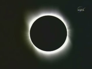
This image taken at 7:10 A.M. shows totality.
Provided by NASA TV
Though the eclipse was not visible in most of North America, NASA TV and the Exploratorium made streaming video of the event available. These images are taken from that video. The Sun appears differently in some of the images because of the different filters used to capture the event. Times listed are ET and approximate.
See NASA’s video of the eclipse here.