Key Takeaways:

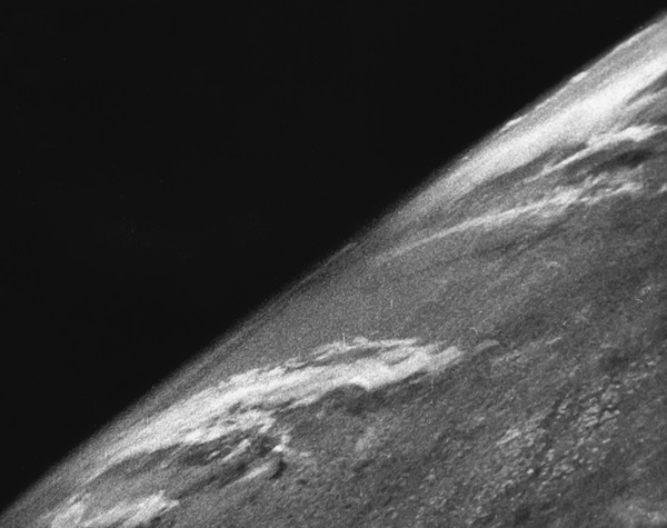
It travelled on a parabolic path that took it 65 miles above Earth, just three miles above the Von Karman line where space begins. When the rocket returned to the ground, most of it was obliterated. But a bit of precious cargo survived inside a steel canister: a roll of film with images of the planet below.
From these beginnings, it would be another 20 years before a bigger feat was accomplished: In 1967, ATS-3 photographed the entire disk of Earth from 22,000 miles above the surface, quite a measure beyond the White Sands test. This image was the first ever released of the whole Earth, all because of a hippie named Stewart Brand.

“I remembered that Buckminster Fuller had been harping on this at a recent lecture — that people perceived the earth as flat and infinite, and that that was the root of all their misbehavior,” he wrote in 1976. “Now from my altitude of three stories and one hundred miles, I could see that it was curved, think it, and finally feel it.
“But how to broadcast it? It had to be broadcast, this fundamental point of leverage on the world’s ills. I herded my trembling thoughts together as the winds blew and time passed. A photograph would do it — a color photograph from space of the earth. There it would be for all to see, the earth complete, tiny, adrift, and no one would ever perceive things the same way.”
Other subsequent images only captured portions of Earth, often half-lit, with large tracts of Earth obscured in darkness. While plenty of breathtaking Earth images came out of the Apollo program, the 1972 image from Apollo 17 has become one of the most iconic. The Blue Marble showed the Earth’s full disk in bright detail, and also marked the first time a human operator was able to take an image of the Earth in this fashion. Given that since Apollo 17 no spacecraft has left Earth orbit, the Blue Marble photo will remain the last of its kind until NASA’s Orion program gets off the ground.
“If you compare the Pale Blue Dot to the Apollo image, you can see the whole planet and you can make out the land shapes and the water shapes and the clouds in Apollo’s,” Suzanne Dodd, program manager for the Voyager program, says. “The one Voyager took, it’s just a pixel. You can’t make out the landscapes or the water. When you look at the Pale Blue Dot, you think ‘this could be any kind of a world.’”
After the image was taken, the Voyager 1 craft prepared for its interstellar mission. Its cameras were shut off, its programming rewritten to conserve power and provide resources for studying the boundaries of the Sun’s influence. Not only was the Pale Blue Dot the last image taken by Voyager, it’s the last image Voyage ever could take.

While there have been a bevy of Earth-observing satellites, NASA had long tried to get DSCOVR off the ground as a climate-purposed satellite. After a decade-and-a-half of abortive starts, the TRIANA program eventually fell to a joint NOAA and NASA effort to keep a constant eye on Earth. The satellite finally launched in 2015, 17 years after it was first proposed.
It was lauded as the first new whole-Earth image in 43 years, since the Blue Marble first wowed audiences. This isn’t quite accurate — many more recent images exist — but it was the first not built from a composite of images taken at different times. The DSCOVR image’s colors were also closer to how human eyes might truly see Earth than the sort of overly bright colors seen in the Blue Marble photo. Jay Herman, instrument specialist for the DSCOVR mission, attributes this detail to the film the Apollo 17 crew used in their Hasseblad cameras, which exaggerated some colors over others in exposures. But there are other differences between DSCOVR images taken by its EPIC instrument and the Blue Marble as well.
“The big difference is, in the Blue Marble they subtracted the atmosphere,” Herman says. “In the DSCOVR EPIC pictures we left it just as you would see it if you looked through a telescope with your eye.”
“We took the sensitivity of the eye to various colors and we balanced it to natural color or eye balance,” Herman says. “It’s basically an aesthetic decision. It’s just as if you took a really good picture with a fine camera.”
Now, nearly 70 years after a V-2 sailed over New Mexico and snapped the first space images of Earth, we have DSCOVR and Japan’s Himari-8 providing continuous views of the entire Earth. In the next decade, a new generation of astronauts may snap those photos if and when the Orion project gets off the ground. For now, there’s still a rich history of seeing our Earth from a perch far above.