The story that has unfolded is a wet one: Mars appears to have had a more massive atmosphere billions of years ago than it does today, with an active hydrosphere capable of storing water in long-lived lakes. The MSL team has concluded that this water helped to fill Gale Crater, the MSL rover Curiosity’s landing site, with sediment deposited as layers that formed the foundation for the mountain found in the middle of the crater today.
Curiosity has been exploring Gale Crater, which is estimated to be between 3.8 billion and 3.6 billion years old, since August 2012. In mid-September 2014, the rover reached the foothills of Aeolis Mons, a three-mile-high layered mountain nicknamed “Mount Sharp” in honor of the late Caltech geologist Robert Sharp. Curiosity has been exploring the base of the mountain since then.
“Observations from the rover suggest that a series of long-lived streams and lakes existed at some point between 3.8 billion and 3.3 billion years ago, delivering sediment that slowly built up the lower layers of Mount Sharp,” said Ashwin Vasavada from MSL. “However, this series of long-lived lakes is not predicted by existing models of the ancient climate of Mars, which struggle to get temperatures above freezing,” he said.
This mismatch between the predictions of Mars’ ancient climate that arise from models developed by paleoclimatologists and indications of the planet’s watery past, as interpreted by geologists, bears similarities to a century-old scientific conundrum — in this case, about Earth’s ancient past.
At the time, geologists first began to recognize that the shapes of the continents matched each other, almost like scattered puzzle pieces, said John Grotzinger from the California Institute of Technology (Caltech) in Pasadena, California. “Aside from the shapes of the continents, geologists had paleontological evidence that fossil plants and animals in Africa and South America were closely related, as well as unique volcanic rocks suggestive of a common spatial origin. The problem was that the broad community of Earth scientists could not come up with a physical mechanism to explain how the continents could plow their way through Earth’s mantle and drift apart. It seemed impossible. The missing component was plate tectonics. In a possibly similar way, we are missing something important about Mars.”
As Curiosity has trekked across Gale Crater, it has stopped to examine numerous areas of interest. All targets are imaged, and soil samples have been scooped from some; the rocks in a select few places have been drilled for samples. These samples are deposited into the rover’s onboard laboratories. Using data from these instruments, as well as visual imaging from the onboard cameras and spectroscopic analyses, MSL scientists have pieced together an increasingly coherent and compelling story about the evolution of this region of Mars.
Before Curiosity landed on Mars, scientists proposed that Gale Crater had filled with layers of sediments. Some hypotheses were “dry,” implying that the sediments accumulated from wind-blown dust and sand, whereas others focused on the possibility that sediment layers were deposited in ancient streams and lakes. The latest results from Curiosity indicate that these wetter scenarios were correct for the lower portions of Mount Sharp. Based on the new analysis, the filling of at least the bottom layers of the mountain occurred mostly by ancient rivers and lakes.
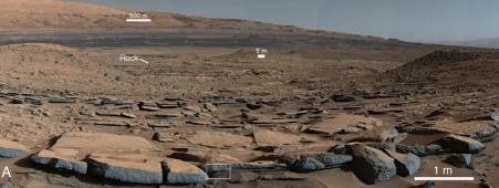
“During the traverse of Gale, we have noticed patterns in the geology where we saw evidence of ancient fast-moving streams with coarser gravel as well as places where streams appear to have emptied out into bodies of standing water,” Vasavada said. “The prediction was that we should start seeing water-deposited, fine-grained rocks closer to Mount Sharp. Now that we’ve arrived, we’re seeing finely laminated mudstones in abundance.” These silty layers in the strata are interpreted as ancient lake deposits.
“These finely laminated mudstones are very similar to those we see on Earth,” said Woody Fischer from Caltech. “The scale of lamination, which occurs both at millimeter and centimeter scale, represents the settling of plumes of fine sediment through a standing body of water. This is exactly what we see in rocks that represent ancient lakes on Earth. “The mudstone indicates the presence of bodies of standing water in the form of lakes that remained for long periods of time, possibly repeatedly expanding and contracting during hundreds to millions of years. These lakes deposited the sediment that eventually formed the lower portion of the mountain.
“Paradoxically, where there is a mountain today there was once a basin, and it was sometimes filled with water,” said Grotzinger. “Curiosity has measured about 75 meters of sedimentary fill, but based on mapping data from NASA’s Mars Reconnaissance Orbiter and images from Curiosity’s cameras, it appears that the water-transported sedimentary deposition could have extended at least 500–650 feet (150–200 meters) above the crater floor, and this equates to a duration of millions of years in which lakes could have been intermittently present within the Gale Crater basin,” Grotzinger said. Furthermore, the total thickness of sedimentary deposits in Gale Crater that indicate interaction with water could extend higher still — up to perhaps 2,600 feet (800 meters) above the crater floor and possibly representing tens of millions of years.
But layers deposited above that level do not require water as an agent of deposition or alteration. “Above 800 meters [2,600 feet], Mount Sharp shows no evidence of hydrated strata, and that is the bulk of what forms Mount Sharp. We see another 13,000 feet (4,000 meters) of nothing but dry strata,” Grotzinger said. He suggested that perhaps this segment of the crater’s history may have been dominated by aeolian, or wind-driven, deposition, as was once imagined for the lower part explored by Curiosity. This occurred after the wet period that built up the base of the mountain.
A lingering question surrounds the original source of the water that carried sediment into the crater. For flowing water to have existed on the surface, Mars must have had a thicker atmosphere and warmer climate than has been theorized for the time frame bookending the intense geological activity in Gale Crater. Evidence for this ancient, wetter climate exists in the rock record. However, current models of this paleoclimate, factoring in estimates of the early atmosphere’s mass, composition, and the amount of energy it received from the Sun, come up, quite literally, dry. Those models indicate that the atmosphere of Mars could not have sustained large quantities of liquid water.
Yet, the rock record discovered at Gale Crater suggests a different scenario. “Whether it was snowfall or rain, you have geologic evidence for that moisture accumulating in the highlands of the Gale Crater rim,” Grotzinger said. In the case of Gale Crater, at least some of the water was supplied by the highlands that form the crater rim, but groundwater discharge — a standard explanation to reconcile wet geologic observations with dry paleoclimatic predictions — is unlikely in this area. “Right on the other side of Gale’s northern rim is the Northern Plains. Some have made the argument that there was a northern ocean sitting out there, and that’s one way to get the moisture that you need to match what we are seeing in the rocks.” Pinpointing the possible location of an ocean, however, does not help to explain how that water managed to exist as a liquid for extended periods of time on the surface.
As climatologists try to develop new atmospheric models, help should be coming from the continuing explorations by Curiosity. “There are still many kilometers of Mars history to explore,” said Fischer. He thinks that some of the most exciting data yet may come in the next few years as Curiosity climbs higher on Mount Sharp. “The strata will reveal Gale’s early history, its story. We know there are rocks that were deposited underwater, in the lake. What is the chemistry of these rocks? That lake represented an interface between the water and the atmosphere, and should tell us important things about the environment of the time.”
“We have tended to think of Mars as being simple,” said Grotzinger. “We once thought of the Earth as being simple, too. But the more you look into it, questions come up because you’re beginning to fathom the real complexity of what we see on Mars. This is a good time to go back to re-evaluate all our assumptions. Something is missing somewhere.”